• Director’s Message

  • SEVINK Vision Institute

  • The Edward M. Kennedy Institute for The US Senate

    PROGRESS WEBCAM

  • SUDI

  • Visitor log

    • 87,815 hits
  • Solidarity with Mali

    We proudly fly The Mali Flag in solidarity with the people of Mali

Guinea Conakry

Guinea, commonly known as La Guinee, to differentiate her from her sister countries Guinea Bissau and Equatorial Guinea, gained independence from France on october 2nd, 1958.

Guinea has had shared histories with Mali, Burkina Faso, Senegal, and Gambia, in the Mali and Songhai empires, and in the French West Africa Federation. Immediately prior to independence, La Guine’e had been part of the community of French colonies called French West Africa along with Mali, Senegal, and Mauritania. By 1956, these former French colonies had limited internal self-government tethered to France for economic, military, and diplomatic policies. When the tide of independence swept across west Africa, French President de Gaulle in 1958 issued the infamous “OUI ou NON” ultimatum. OUI(yes) you are for maintaining the status quo of French custodianship of your international affairs, or NON(no) you oppose such a paternalistic arrangement. Unlike other nations, this ultimatum yielded an emphatic NON from Guinea. As precursor to her “NON” decision, Sekou Toure, who was deputy-mayor of Conakry, delivered a a legendary speech to the French President which is akin to the Declaration of Independence of the 13 colonies of America, of which Georgia was the 13th state. See the text of this speech in English on our Profiles in Democracy page later. The emphatic “NON” from Sekou Toure and Guinea would incur the wrath of France and de-Gaulle ordered all French nationals to leave Guinea with all technical files and survey and logistic documents. Even the phone cords were ripped off the walls. Guineans were astonished, disappointed and grew ever-suspicious of the French. Sekou Toure became the first President of Guinea at independence and France and Guinea severred all ties. Guinea followed the path of Socialist Democracy and allied herself with the Soviet Bloc. The crimes of France against Guinea was to endear Sekou Toure to the African diaspora and may have accelerated the quest for the total decolonisation of Africa save for Southern African nations. On march 26th, 1984, Sekou Toure died and his Prime Minister Lansana Beavogui was designated chief of government. A week later, on April 3rd, current president Lasana Conte’ staged a bloodless coup. To garner public support for the military government, Conte’ had a more liberal dispensation and he freed former political prisoners and invited exiled Guineans back to Guinea. However, after two unsuccessful attempted coups in 1985 and 1996, his resolve hardened and Conte adopted Sekou Toure’s autocratic disposition. Conte’ has now served three consecutive terms as president of Guinea.

Guinea’s honorable history was again marred by insurgency from the Sierra Leone-Liberia war of 2000 when Guinea was host to multitudes of refugees from the two warring countries.

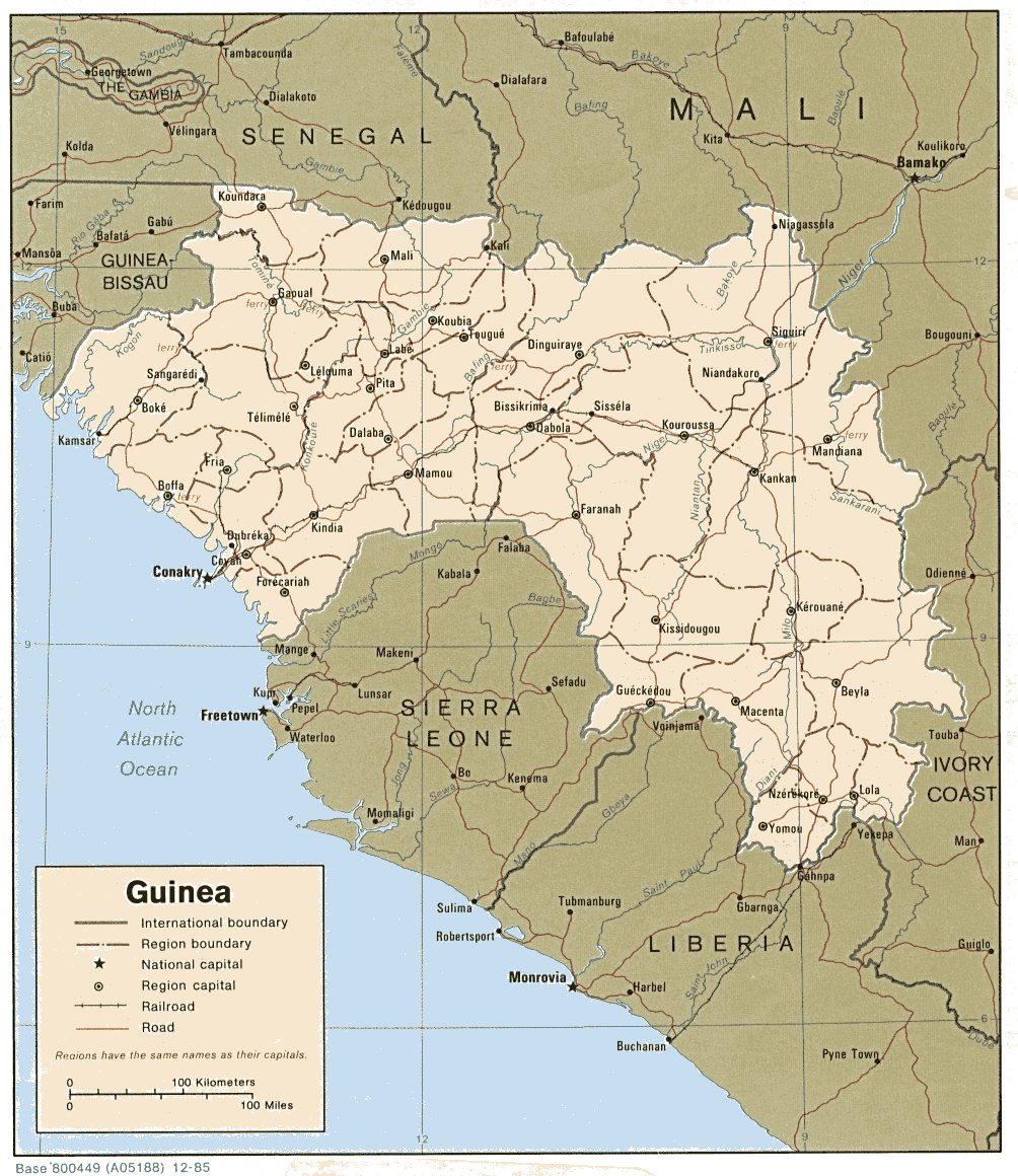
Bordered by Guinea Bissau (~200mi) in the northwest, Senegal (~180mi), Mali (~450mi) in the north and east, Ivory Coast (~350mi) in the east, Liberia (~300mi) in the south, Sierra Leone (~450mi) also in the south, and the Atlantic Ocean (~250mi) in the west,

ROP-1 Africa Partners

much of northern Guinea hosts the expansive and legendary Fouta Djallon Mountain ranges which stretches from Southern Mali through central Guinea and into northern Sierra Leone and northeastern Liberia. Indeed the Fouta Djallon highlands hosts the headwaters of most of West Africa’s river system to include The Niger, Senegal, Gambia, Bafing, Koulountou, Geba, Bakoye, Mongo, and Konkoure’ rivers and their prime tributaries. The capital of Guinea is Conakry.

Guinea’s most significant preoccupations are warding off alleged and incessant destabilization schemes by France, sporadic insurgencies from her neighbors Sierra Leone and Liberia, and the fiduciary responsibility as West Africa’s River keeper. Relations with France have smoothed over the last few years but La Guinea contends with how to maintain a free nation based on democratic principles with suspicions of French subversive activity lingering.

___________________________________________________________________

Please click on the link below to view a map of Guinea Conakry

http://www.africa.upenn.edu/CIA_Maps/Guinea_19847.gif

___________________________________________________________________

GUINEA Facts 

Population:  approx. 10,300,000                   

Latitude:   between 8 deg. N and 11.5 deg. N

Longitude: 2 deg. E and 5.5 deg. E

Highest pt: Mount Nimba (1,752m / 5,256 ft.)

Land Area: 245,857 sq. km (94,926 sq. mi.)

Coastline: 300 km (190 mi) Atlantic

Average Annual Rainfall: 1835 mm

   Rainy Season – May to October with SW Monsoon winds

   Dry Season – Nov. to April with NE Harmattan winds

President of La-Guinea: HE Alpha Conde’

Airport: Conakry-Gbessia   Seaports: Conakry & Kamsar

____________________________________________________________

Guinea Climate:

TOPOGRAPHY

Guinea’s landscape offers four distinct topographies as described below:

1. Lower Guinea represents approx. 18% of Guinea’s total landmass and comprises an alluvial Coastal Plain which rises in stepped plateaus toward the northeastern highlands.

2. Fouta Djallon Massif which is a series of stepped gneiss plateaus cut by valleys and gorges to form the mountain range of the same name. The Highlands cover most of the Guinea midlands (Moyenne-Guinee) to form the bulk of Guinea’s northern Sierra Leone border and accounting for approximately 20% of the country’s total land area.

3. Upper Guinea (Haute-Guinee) forms the eastern plateaus of the Fouta Djallon Massif toward the Forested northern Ivory Coast border and the grassy Savannahs of the Mali border. Upper Guinea makes up approximately 38% of Guinea’s total land area.

4. The forested Highlands are the natural extension of the Fouta Djallon Massif and the Upper-Guinea plateaus. It extends south to form Guinea’s eastern Liberia border and western Ivory Coast border where the highest point NIMBA is located.

___________________________________________________________________

Natural Resources:

PEOPLE:                                                        

Africans (Fulani/Peul, Malinke, Sousou, Kissi, Kpelle, Loma)

Europeans

North and South Americans

Canadians

Asians (Chinese, Indian, Korean)

Middleeastern

Languages:

French is the official language of Guinea

Pulaar, Malinke, Soussou, Kissi, Guerze, Toma, Koniagui, Soninke.

RELIGION:

Islam – 85%

Catholic, Anglican, Baptist, Seventh Day Adventist, Jehovah’s Witness, Hindu, Buddhist, and Bahai – 10%

Traditional and Non-denominational – 5%

WATER

Headwaters for The Gambia River, Senegal River, Niger River, Bafing River, Mano River, Sankarani River, the Corubal River, the Saint Paul River, Geba River, Koulountou River, and Bakoye River.

Significant proprietary rivers such as the Konkoure River, Kogon River, the Gbanhala River, Nunez river, Fatala river, the Tinkisso River, Yeremou river, Kourd river, Bala River, the Milo River.

___________________________________________________________________

Guinea has 7 administrative Regions which are further subdivided into 33 prefectures and the District of Conakry, the capital.